Just when we were settling into what felt like an early spring, the atmosphere had other plans. Last Thursday - March 12 - Richmond experienced one of the more dramatic weather shifts in recent memory: a textbook weather whiplash, start to finish in a single day.
From balmy morning to winter wonderland # #
The day opened quietly. At 7:00 AM, the temperature sat at a comfortable 75°F, a southwest breeze carrying the particular warmth that makes you believe, wrongly, that winter is done. People were out in t-shirts. The air had that loose, unhurried quality of a morning that doesn’t know what’s coming.
By 9:00 AM, the wind had shifted sharply to the north. What followed wasn’t a gradual cooling - it was a door swinging shut. Within a few hours, the mercury had dropped from the 70s into the 30s. By early afternoon, the rain had turned to snow, and the Virginia landscape wore a brief, incongruous coat of white.
The cold front: a natural phenomenon # #
The mechanism behind this was a classic cold front - the leading edge of a denser, colder air mass. In this case, a Canadian high-pressure system had funneled south down the East Coast with unusual force. That air mass behaved like a wedge, driving under the warmer surface air and forcing it upward sharply. The rapid lift, the temperature gradient, the wind reversal - all of it followed from that single collision.
A “Blue Norther” # #
There’s a name for this kind of event in the Great Plains: a Blue Norther - a rapidly advancing arctic cold front that can drop temperatures by 20°F to 40°F in minutes rather than hours. The name is thought to come from the appearance of the approaching front: a dark, blue-black wall of cloud at the horizon, with a deep, cold blue sky trailing behind it.
The Mid-Atlantic doesn’t see Blue Northers often. Our geography softens most of what comes down from Canada. But last Thursday’s front was close kin - the physics identical, the drama nearly so. It’s worth imagining that wall of cloud pushing south from the Plains, crossing the Appalachians, arriving here with its name still on it.
Visualizing the front # #
The most effective way to see the impact of this cold front is to look at a meteogram, which is a graph that plots weather variables over time. Here’s one I drew using data from Richmond International Airport:
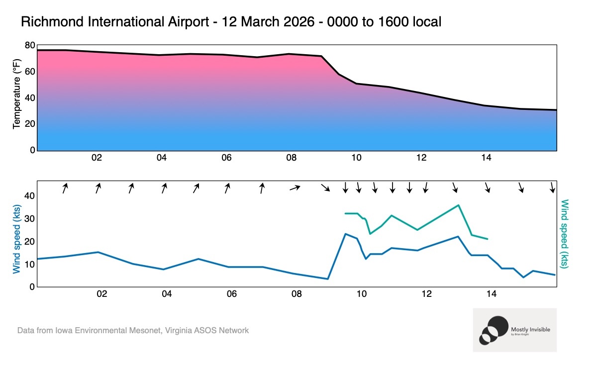
The temperature drop around 9:00 AM is the sharpest feature. Notice too the simultaneous wind direction shift - southwest to north - which marks the exact moment the front arrived.
False Spring # #
Richmond sits in an odd meteorological position: close enough to the coast to stay warm, open enough to the north to get blindsided. We’re known for false springs - teasing warm stretches in February and March that dissolve overnight. But a 40-degree drop in six hours is extreme even by local standards.
The cold front that moved through last Thursday was a reminder that the atmosphere doesn’t negotiate. It arrives, it changes everything, and then it’s gone - leaving snow on the ground and everyone reaching back into the closet for a coat they thought they were done with.